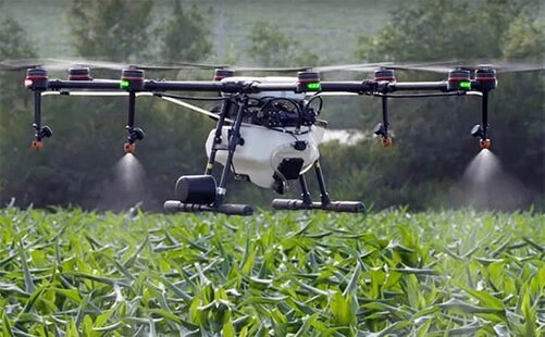
In the age of smart farming, Farmer Drone Surveillance is emerging as a game-changer for agriculture. By leveraging unmanned aerial vehicles (UAVs), farmers can monitor crop health, identify issues, and make informed decisions—cutting crop monitoring time by up to 70%. This innovative technology is revolutionizing traditional farming practices and offering a sustainable solution to age-old agricultural challenges.
This article explores how Farmer Drone Surveillance works, its benefits, real-life use cases, and why it is becoming essential for modern-day agriculture.
1. How Farmer Drone Surveillance Works
Farmer Drone Surveillance involves using drones equipped with high-resolution cameras, infrared sensors, and AI-powered analytics. Here’s how it functions:
Step-by-Step Drone Surveillance Process:
- Pre-Flight Planning: Farmers select the area to be scanned using GPS-enabled software.
- Aerial Surveying: The drone flies over the fields and captures detailed images of crops.
- Data Processing: Captured data is analyzed through software to detect:
- Crop stress
- Pest infestation
- Watering issues
- Actionable Insights: Farmers receive a visual report highlighting problem areas for immediate intervention.
2. Benefits of Farmer Drone Surveillance
Here are the top advantages of using drone technology in farming:
| Benefit | Impact |
|---|---|
| Reduced Crop Monitoring Time | Up to 70% faster than manual inspection |
| Improved Crop Yields | Early detection leads to timely treatment |
| Cost Efficiency | Reduces labor and chemical costs |
| Precision Agriculture | Enables targeted interventions |
| Enhanced Soil and Field Analysis | Detects drainage, soil variation, and more |
| Remote Monitoring | Ideal for large or hard-to-access farms |
3. Key Applications of Farmer Drone Surveillance
Farmer Drone Surveillance isn’t limited to just aerial images. It has diverse applications across farming operations:
Major Use Cases:
- Crop Health Monitoring
Detects stress levels, disease, or pest infestations early. - Plant Counting and Density Mapping
Helps optimize planting strategies and measure productivity. - Irrigation Monitoring
Identifies dry spots and irrigation issues. - Soil Health Analysis
Maps nutrient levels and identifies areas requiring fertilization. - Yield Prediction
Uses AI to forecast potential output before harvesting.
4. Drone Technology Used in Agriculture
Let’s look at the common types of drones and sensors used:
| Type of Drone/Sensor | Purpose |
|---|---|
| Multispectral Cameras | Assess plant health using NDVI imaging |
| Thermal Sensors | Identify irrigation issues |
| RGB Cameras | Capture high-resolution images |
| Fixed-Wing Drones | Ideal for large farm areas |
| Rotary Drones | Best for precision tasks |
5. Real-World Impact: Case Studies
Case Study 1: Punjab, India
A sugarcane farmer using drone surveillance reported:
- 60% reduction in pesticide use
- 25% increase in crop yield
- 70% time saved in crop inspections
Case Study 2: California Vineyards
Drone mapping helped detect mildew early, saving nearly $20,000 per season in fungicide costs and losses.

6. Challenges in Implementing Farmer Drone Surveillance
Despite its benefits, there are some limitations:
- Initial Investment Costs
Equipment and software can be expensive. - Skill Requirement
Farmers need training to operate and analyze drone data. - Weather Dependency
Rain or strong winds can disrupt drone operations. - Regulatory Restrictions
Some countries have airspace rules for UAVs.
7. Farmer Drone Surveillance vs Traditional Monitoring
| Aspect | Traditional Monitoring | Drone Surveillance |
|---|---|---|
| Time Taken | 5–6 hours per acre | 1–2 hours per acre |
| Data Accuracy | Subjective and visual | High-resolution and analytical |
| Labor Requirements | High | Low |
| Cost Over Time | Increases with manpower | Reduces due to automation |
| Scalability | Limited | Easily scalable for large areas |
8. How to Get Started with Farmer Drone Surveillance
If you’re a farmer looking to implement this, here’s how to start:
Getting Started Checklist:
- ✅ Choose a drone model suited for agriculture (e.g., DJI Agras, Parrot Bluegrass)
- ✅ Invest in mapping and analytics software (e.g., DroneDeploy, Pix4D)
- ✅ Get training or hire a certified drone operator
- ✅ Understand local drone regulations
- ✅ Start with small field trials before scaling up
9. Frequently Asked Questions (People Also Ask)
What is farmer drone surveillance?
Farmer Drone Surveillance uses drones to collect data and monitor crop health efficiently and quickly.
How much time does drone surveillance save?
Drone technology can cut crop monitoring time by up to 70%, depending on the farm size and terrain.
Are drones accurate for crop analysis?
Yes, drones equipped with multispectral and thermal sensors provide high-accuracy data and real-time insights.
Do I need a license to fly a drone for farming?
In most countries, yes. Licensing and regulations vary, so check with your local aviation authority.
10. Related Topics (People Also Search For)
- Smart farming technologies
- Precision agriculture
- AI in agriculture
- Agricultural drones in India
- NDVI drone crop monitoring
- Farm automation tools
- Sustainable agriculture solutions
Conclusion: The Future of Farming Is in the Skies
With rising demands for food and sustainable practices, Farmer Drone Surveillance is no longer a luxury—it’s a necessity. By cutting monitoring time by up to 70%, it not only saves time and money but also improves crop health and yields. As technology becomes more affordable and regulations become farmer-friendly, drones will be an everyday tool for agriculture.
At Chandigarh UT, we believe in empowering farmers with knowledge and innovation. Whether you’re a small-scale grower or a large agribusiness, now is the time to explore drone-based surveillance for a smarter, faster, and more productive farming future.